
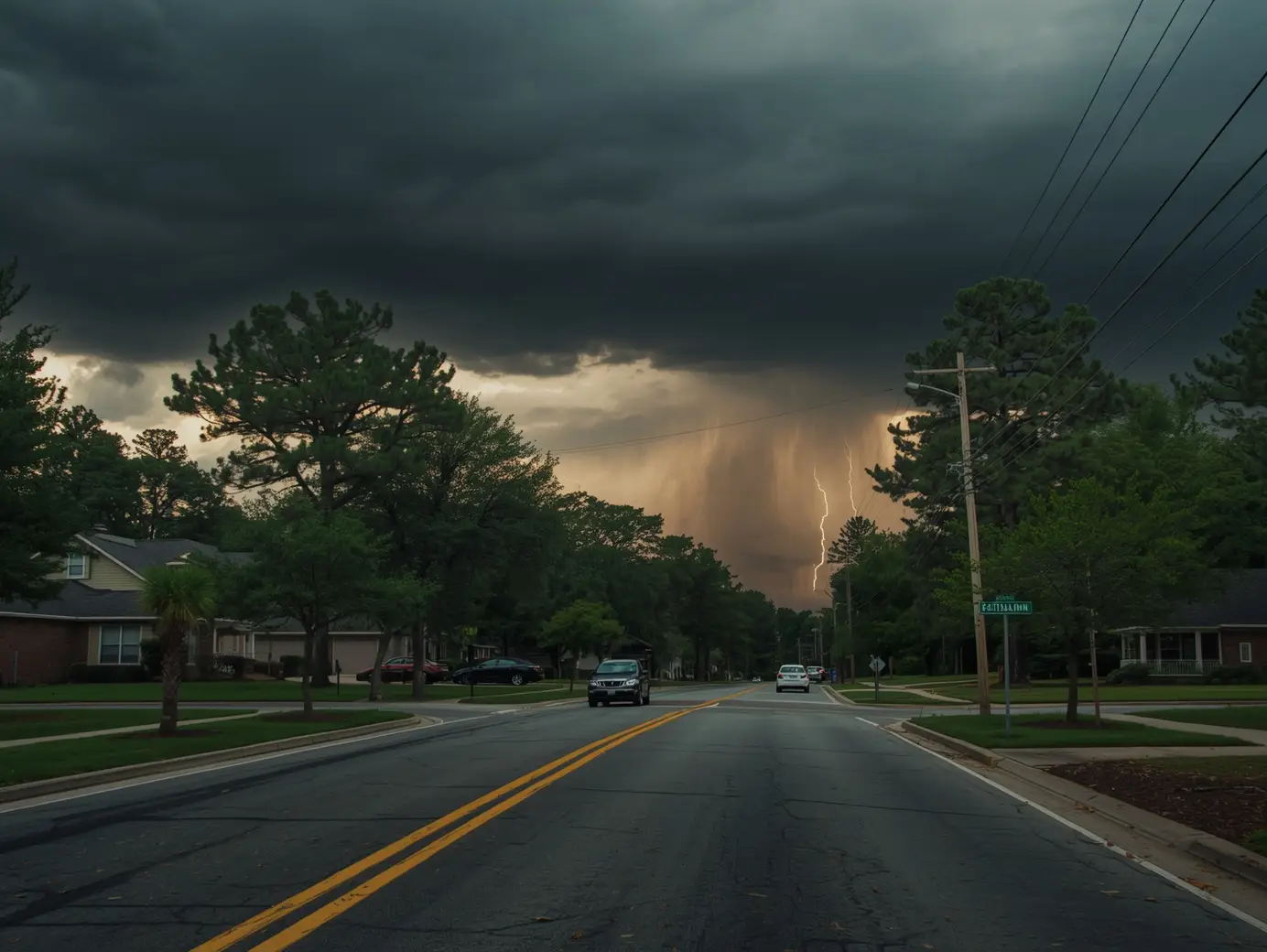
South Carolina weather can flip fast—blue skies one minute, roaring wind and pounding rain the next. That’s why the latest round of severe thunderstorm alerts matters: they’re not “just rain,” and they’re not background noise.
Multiple severe thunderstorm alerts have been issued for several South Carolina counties as storm conditions increase. These alerts are typically issued by the National Weather Service when storms may produce damaging winds, hail, and heavy rain. If you’re in an affected county, get inside, stay away from windows, charge devices, and avoid driving through flooded spots. Keep checking local updates until the threat passes.
What’s going on in South Carolina right now
A growing storm threat has triggered multiple severe thunderstorm alerts across South Carolina, putting residents on notice for dangerous weather that can intensify quickly. The concern isn’t just lightning and loud thunder—these storms can bring damaging wind gusts, hail, and downpours heavy enough to cause localized flooding and power outages.
The alerts highlighted Greenville, Spartanburg, York, Lancaster, and Charleston County as areas impacted by the warnings.
In the middle of all the noise online, it helps to stick with clear, verified guidance. This coverage is based on reporting from Multiple Severe Thunderstorm Alerts Issued for South Carolina Counties and shaped for practical, local use—because families still have pickups, commutes, pets, and dinner to manage even when the sky turns rough.
Multiple Severe Thunderstorm Alerts Issued for South Carolina Counties: What it means for residents
“Severe thunderstorm alert” is often used as a general phrase, but the key idea is simple:
What is a severe thunderstorm alert
A severe thunderstorm alert is a heads-up that storms in your area may become dangerous—especially due to:
- Damaging winds (strong enough to snap limbs, topple weak trees, or knock out power)
- Hail (which can damage cars, roofs, and windows)
- Heavy rain (which can overwhelm drains and create fast, surprise flooding)
In the report that prompted this article, the alerts were tied to storms capable of producing wind gusts above 58 mph and hail larger than one inch—two classic markers used when storms cross into “severe” territory.
What triggers these alerts
Alerts can be issued when weather data and reports suggest storms are meeting or nearing severe thresholds, often based on:
- Radar showing a strengthening storm line or storm cores
- Storm spotter or public reports of wind/hail damage
- Rapidly intensifying storm movement toward populated areas
You don’t need to be a weather expert. You just need to treat the alert like a real-life timer.
Severe thunderstorm watch vs. warning
People mix these up all the time—understandably. Here’s the clean difference:
Severe thunderstorm watch
A watch means conditions are favorable for severe storms to form.
Think: “Be ready. Keep your phone on. Make a plan.”
Severe thunderstorm warning
A warning means severe weather is happening or about to happen in your area.
Think: “Take action now. Get to a safer place.”
If you remember only one thing: A watch is preparation. A warning is protection.
Counties mentioned in the alerts
The report named these South Carolina areas as affected:
- Greenville
- Spartanburg
- York
- Lancaster
- Charleston County
If you have family spread across the Upstate and the coast, this kind of list matters—because it signals a broader, multi-region storm setup. One county might get slammed with wind while another deals with flash flooding just a few miles away.
What to do now
If you’re under a severe thunderstorm warning or expect storms soon, do these in order:
- Go indoors immediately and keep everyone away from windows.
- Charge your phone and power banks, and keep a flashlight handy.
- Secure outdoor items (chairs, trash cans, grills) if it’s still safe to do so.
- Pause travel plans—especially if heavy rain is already falling.
- Monitor official alerts until the warning expires or conditions clearly improve.
Three short, quotable safety lines
- “If thunder is loud, you’re close enough to lightning—get inside.”
- “Treat every warning like it’s headed straight for your street.”
- “Turn around, don’t drown—flooded roads are deeper than they look.”
How these storms can hit day-to-day life in South Carolina
Severe thunderstorms don’t just bring dramatic skies—they disrupt routines. Here’s what to plan for in the most South Carolina way possible: home, roads, school runs, and pets.
At home: protect people first, property second
When wind is strong enough to break limbs and toss debris, the danger isn’t only outside.
Do this at home:
- Move to an interior room (no windows) if winds intensify
- Keep shoes nearby (broken glass happens)
- Avoid showers and corded devices during lightning
- Set the fridge/freezer colder if outages seem likely
- Park vehicles in a garage or away from trees if you have time
On the road: heavy rain changes everything
South Carolina storms can dump a lot of rain quickly, and drainage can’t always keep up—especially in low spots and near underpasses.
Driving safety during severe storms:
- Slow down early—hydroplaning can happen fast
- Never cross water-covered roads (even shallow-looking ones)
- Give extra distance to trucks (wind gusts can push vehicles)
- If visibility drops hard, pull off safely and wait it out
School pickups and after-school plans
Storm timing loves to collide with pickup lines.
Smart moves for parents and caregivers:
- Charge your phone before dismissal time
- Keep a small “storm kit” in the car (water, flashlight, basic first aid)
- If a warning is active, prioritize shelter over rushing to beat the rain
- Have a backup plan for who can pick up if roads become unsafe
Pets and livestock: don’t forget the backyard
Animals often panic during thunder and wind.
Pet prep that actually helps:
- Bring pets inside early—before thunder starts
- Keep leashes handy (scared pets bolt)
- Create a calm corner with a blanket or crate
- If you have outdoor animals, check fencing and shelter stability
Indoor vs. outdoor safety: the simple rules
If you’re indoors
- Stay away from windows and glass doors
- Avoid using plugged-in electronics if lightning is close by
- Keep kids and pets in a central area
- Use flashlights instead of candles if the power goes out
If you’re outdoors
- Get to a sturdy building or a hard-topped vehicle fast
- Do not shelter under trees
- Avoid open fields, hilltops, and bodies of water
- If you’re at a park or ball field, leave early—don’t wait for the first strike
Severe Thunderstorm Alert: Fast Safety Checklist
| Situation | What it means | What to do in the next 10 minutes |
| You receive a severe thunderstorm warning | Severe weather is happening or imminent in your area | Go indoors, move away from windows, grab a flashlight, check on family/pets |
| Winds suddenly pick up, and debris starts moving | Storm core may be arriving; falling branches are possible | Get to an interior room, avoid glass, put on shoes, keep helmets handy for kids if available |
| Hail begins (or is reported nearby) | Roof/window/vehicle damage risk increases | Move vehicles under cover if safe, stay inside, keep away from skylights/windows |
| Power flickers or goes out | Lines/trees may be impacted; the outage could last | Unplug sensitive electronics, keep fridge closed, use a flashlight, check with neighbors if safe |
| Heavy rain overwhelms streets | Localized flooding and stranded cars become more likely | Avoid driving, move to higher ground if water rises, monitor alerts |
| You’re driving, and visibility drops | Hydroplaning and crashes become more likely | Slow down, increase distance, pull over safely if needed—don’t stop under trees |
Why “severe” storms can feel random
Two neighborhoods can have completely different experiences because storms are messy. A single line of storms can produce:
- A burst of damaging wind in one spot
- A hail core a few miles away
- Flash flooding in low-lying areas
- Downed trees where the ground is already saturated
That’s why county-based alerts matter: they’re broad enough to cover fast-changing conditions, even when the worst impacts are localized.
Preparedness you can do in calm weather
If South Carolina storm season keeps you on edge, a few small habits make a big difference.
A quick “before storms” home list
- Keep flashlights in two places (kitchen + bedroom)
- Store a portable charger where you can find it fast
- Know where you’ll go if windows start rattling (hallway, closet, bathroom)
- Trim weak branches if you can (or get them checked)
- Save emergency contacts and local utility numbers in your phone
What to keep in a simple car kit
- Flashlight
- Phone charger cable
- Small first-aid kit
- Bottled water
- Blanket (surprisingly useful if stranded)
FAQs
1) What does “Multiple Severe Thunderstorm Alerts Issued for South Carolina Counties” mean?
It means more than one alert has been issued for different areas of South Carolina due to a growing storm threat. These alerts signal storms that may produce damaging winds, hail, and heavy rain. If you’re in an affected county, you should monitor updates and be ready to take shelter quickly.
2) Which South Carolina counties were named in the alerts?
The report identified Greenville, Spartanburg, York, Lancaster, and Charleston County. If you live nearby, storms can still shift, so don’t ignore alerts just because your exact town isn’t listed. Use alerts as a “close enough to act” signal.
3) What’s the difference between a severe thunderstorm watch and a warning?
A watch means conditions are favorable for severe storms to form—stay ready. A warning means severe weather is occurring or imminent—take action now. If you’re unsure which one you have, treat it like a warning and move to a safer place.
4) What should I do first when a severe thunderstorm warning pops up?
Go indoors immediately and move away from windows. Charge your phone if you can, grab a flashlight, and keep shoes nearby in case of broken glass or debris. Then keep checking updates until the warning expires.
5) Can severe thunderstorms cause power outages in South Carolina?
Yes. Strong wind gusts can bring down limbs and trees, and lightning can impact lines and equipment. Prepare for outages by charging devices, having flashlights ready, and keeping your refrigerator closed as much as possible if power drops.
6) Is it safe to drive during a severe thunderstorm?
It depends on conditions, but it’s often riskier than people think—especially in heavy rain. Visibility can drop fast, and water-covered roads can hide deep spots. If a warning is active, delaying travel is usually the safer choice.
7) What size hail and wind speeds are considered “severe”?
In the referenced reporting, storms were tied to markers like wind gusts above 58 mph and hail larger than one inch. Those levels can damage roofs, vehicles, and windows. Even smaller hail can be dangerous when driven by strong wind.
8) What’s the safest place in my house during severe storms?
Choose an interior room on the lowest level, away from windows—like a hallway, closet, or bathroom. The goal is to avoid glass and reduce exposure to flying debris. If you have kids, bring them (and pets) into that space early so you’re not moving around during the worst part.
Key Takeaways
- Multiple severe thunderstorm alerts were issued for parts of South Carolina, including Greenville, Spartanburg, York, Lancaster, and Charleston County.
- Severe storms can bring damaging winds, hail, heavy rain, flash flooding, and power outages—sometimes with little warning.
- Remember: watch = be ready, warning = take action now.
- Best immediate move: get indoors, stay away from windows, charge devices, and avoid driving through heavy rain or flooded roads.
- A simple plan for home, driving, school pickups, and pets makes storm days less stressful and a lot safer.